


4T Trail
Trains, trails, trams and trolleys — oh my!
The unique 4T trail (the four “Ts” being a trail, tram, trolley and train) is a self-guided urban nature tour that lets you explore the city — and see some of the best views — without a car. It takes about four hours, $13.60 and a bit of leg power. The route is well-marked with signs and includes about 2.5 miles (4 km) of walking. (Visit here for a map of the trail.) Here’s an overview:
Train
Starting downtown, catch the MAX light rail (Red or Blue line) from Pioneer Courthouse Square (or nearby) to the Oregon Zoo stop. (Purchase an all-day pass for $5.60 before boarding — this is good for the train and the streetcar.) The zoo stop is 260 feet (79 m) below ground level in the nation’s deepest tunnel. Ride the elevator to the surface, where you can explore the zoo before following the “4T” signs for the next leg of the journey.
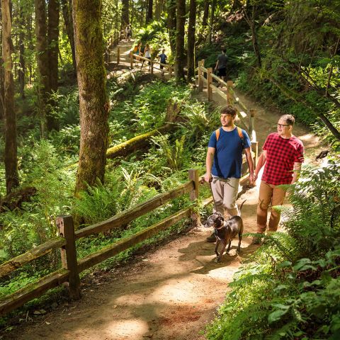
As you rest your legs from the moderately steep, hour-long climb, you can savor some of the city’s best views.
Trail
Head downhill, across the Highway 26 overpass, and exit the city landscape on the well-maintained Marquam Trail (also signed for the 4T). You’ll hike 1.3 miles (2 km) up a wooded trail to Council Crest Park, the highest point in Portland at 1,073 feet (327 m). As you rest your legs from the moderately steep, hour-long climb, you can savor some of the city’s best views. Why not bring along a brown bag lunch if you so desire?
More Hikes and Trails
For a dose of outdoor recreation, head to these favorite local trails and hiking spots.
Hikes in and Near Portland
With easy access to the great outdoors, Portland is a perfect destination for hikers — explore the city’s urban walks, verdant parks and lush gardens, or escape to the nearby gorge and mountains.

Hoyt Arboretum: Portland’s Museum of Trees
Hoyt Arboretum is Portland’s “living museum of trees” — and is home to 2,300 species of trees and shrubs, as well as 12 miles (19.3 km) of hiking trails in Washington Park near downtown Portland.

Soft Hiking in Portland
A collection of accessible soft hikes perfect for leisurely strolls, low-impact exercise and lots of meandering dilly-dallying.
Tram
The aerial tram’s shiny, pod-like cars whisk passengers downhill while providing panoramic views of the Willamette River and Southeast Portland. On a clear day, you can even see Mount Hood in the distance. One-way fares aren’t available on the tram, so you’ll need to purchase a round-trip pass from the terminal (which costs $8 each). Note: The tram runs Monday-Saturday year-round. Visit www.gobytram.com for a full schedule.
Walk downhill from Council Crest, crossing Southwest Greenway and Fairmont streets, and pick between 1) following the trail on a 2.2-mile (3.5 km) hike through hilly Marquam Nature Park or 2) taking a 1.6-mile (2.6 km) walk downhill on city streets without sidewalks. Both paths lead to the Oregon Health & Science University (OHSU) campus, where 4T signs point to the upper terminal of the Portland Aerial Tram. (Tip: there are also public restrooms available at OHSU.)
Trolley
The final mode of transport is the Portland Streetcar, which you can board from the stop near the tram terminal. Running about every 15 minutes, the European-style streetcar — or trolley — will carry you back to downtown Portland, only one stop from your starting point at Pioneer Courthouse Square.
Download a description and map of the route.
Getting Around
Explore Portland like a local by using TriMet, the city's public transportation system.
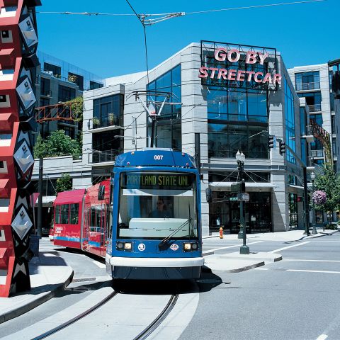
Portland Streetcar
The City of Roses built the nation’s first modern-day streetcar in 2001: the sleek and modern Portland Streetcar.
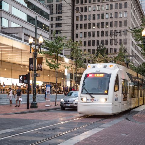
MAX Light Rail
Portland’s efficient light rail system connects the metro area and downtown core. Learn how to ride and where to go on MAX.

Biking
One of the best ways to explore the Rose City is on two wheels.https://en.wikipedia.org/wiki/24_Hour_Party_People
Was this page helpful?